|
|
|||||||||||||||||
| Point ID: 6580 | Downloads | Plots | Site Data | Code: 9279 |
|
|
|||||||||||||||||
| Download | |
|---|---|
| Site Descriptor Information | Site Time Series Data |
| Link to all available data | |
| View: | Time Series | All |
| Units: | m3/s |
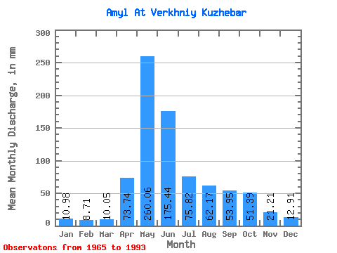
| Statistic | Jan | Feb | Mar | Apr | May | Jun | Jul | Aug | Sep | Oct | Nov | Dec | Annual |
|---|---|---|---|---|---|---|---|---|---|---|---|---|---|
| Mean | 10.98 | 8.79 | 10.05 | 73.74 | 260.02 | 175.44 | 75.81 | 62.16 | 53.95 | 51.39 | 21.21 | 12.91 | 813.21 |
| Standard Deviation | 2.15 | 1.21 | 1.83 | 33.56 | 68.31 | 92.03 | 29.77 | 26.93 | 27.18 | 25.34 | 8.50 | 2.92 | 154.26 |
| Min | 7.27 | 7.18 | 7.22 | 12.44 | 147.37 | 64.92 | 28.71 | 18.34 | 25.33 | 21.29 | 11.90 | 7.11 | 533.59 |
| Max | 15.30 | 11.90 | 14.79 | 132.80 | 417.71 | 444.13 | 154.99 | 109.25 | 152.47 | 128.06 | 40.67 | 19.51 | 1155.05 |
| Coefficient of Variation | 0.20 | 0.14 | 0.18 | 0.46 | 0.26 | 0.53 | 0.39 | 0.43 | 0.50 | 0.49 | 0.40 | 0.23 | 0.19 |
 Return to R-Arctic Net Home Page