|
|
|||||||||||||||||
| Point ID: 6577 | Downloads | Plots | Site Data | Code: 9256 |
|
|
|||||||||||||||||
| Download | |
|---|---|
| Site Descriptor Information | Site Time Series Data |
| Link to all available data | |
| View: | Time Series | All |
| Units: | mm |
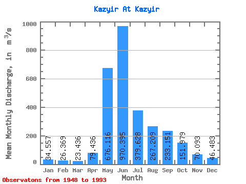
| Statistic | Jan | Feb | Mar | Apr | May | Jun | Jul | Aug | Sep | Oct | Nov | Dec | Annual |
|---|---|---|---|---|---|---|---|---|---|---|---|---|---|
| Mean | 34.56 | 26.37 | 23.44 | 79.44 | 676.12 | 970.39 | 379.63 | 267.21 | 233.15 | 151.98 | 70.09 | 46.48 | 247.37 |
| Standard Deviation | 5.64 | 3.81 | 3.52 | 49.47 | 196.89 | 295.99 | 116.10 | 97.21 | 103.02 | 61.73 | 17.98 | 7.48 | 37.82 |
| Min | 25.30 | 17.10 | 15.20 | 20.10 | 188.00 | 439.00 | 195.00 | 113.00 | 84.50 | 71.90 | 31.90 | 26.60 | 183.14 |
| Max | 49.20 | 36.30 | 31.90 | 189.00 | 1290.00 | 1890.00 | 662.00 | 549.00 | 636.00 | 428.00 | 114.00 | 61.60 | 333.02 |
| Coefficient of Variation | 0.16 | 0.14 | 0.15 | 0.62 | 0.29 | 0.30 | 0.31 | 0.36 | 0.44 | 0.41 | 0.26 | 0.16 | 0.15 |
 Return to R-Arctic Net Home Page