|
|
|||||||||||||||||
| Point ID: 6577 | Downloads | Plots | Site Data | Code: 9256 |
|
|
|||||||||||||||||
| Download | |
|---|---|
| Site Descriptor Information | Site Time Series Data |
| Link to all available data | |
| View: | Time Series | All |
| Units: | m3/s |
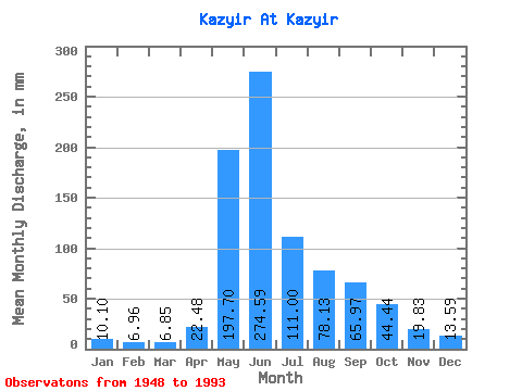
| Statistic | Jan | Feb | Mar | Apr | May | Jun | Jul | Aug | Sep | Oct | Nov | Dec | Annual |
|---|---|---|---|---|---|---|---|---|---|---|---|---|---|
| Mean | 10.10 | 7.02 | 6.85 | 22.48 | 197.67 | 274.59 | 110.99 | 78.12 | 65.97 | 44.43 | 19.83 | 13.59 | 852.28 |
| Standard Deviation | 1.65 | 1.01 | 1.03 | 14.00 | 57.56 | 83.75 | 33.94 | 28.42 | 29.15 | 18.05 | 5.09 | 2.19 | 130.32 |
| Min | 7.40 | 4.55 | 4.44 | 5.69 | 54.96 | 124.22 | 57.01 | 33.04 | 23.91 | 21.02 | 9.03 | 7.78 | 631.00 |
| Max | 14.38 | 9.67 | 9.33 | 53.48 | 377.14 | 534.81 | 193.54 | 160.50 | 179.97 | 125.13 | 32.26 | 18.01 | 1147.38 |
| Coefficient of Variation | 0.16 | 0.14 | 0.15 | 0.62 | 0.29 | 0.30 | 0.31 | 0.36 | 0.44 | 0.41 | 0.26 | 0.16 | 0.15 |
 Return to R-Arctic Net Home Page