|
|
|||||||||||||||||
| Point ID: 6567 | Downloads | Plots | Site Data | Code: 9204 |
|
|
|||||||||||||||||
| Download | |
|---|---|
| Site Descriptor Information | Site Time Series Data |
| Link to all available data | |
| View: | Time Series | All |
| Units: | mm |
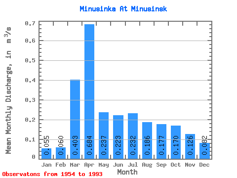
| Statistic | Jan | Feb | Mar | Apr | May | Jun | Jul | Aug | Sep | Oct | Nov | Dec | Annual |
|---|---|---|---|---|---|---|---|---|---|---|---|---|---|
| Mean | 0.06 | 0.06 | 0.40 | 0.68 | 0.24 | 0.22 | 0.23 | 0.19 | 0.18 | 0.17 | 0.13 | 0.08 | 0.20 |
| Standard Deviation | 0.04 | 0.05 | 0.43 | 0.59 | 0.12 | 0.07 | 0.15 | 0.07 | 0.05 | 0.04 | 0.06 | 0.06 | 0.06 |
| Min | 0.00 | 0.00 | 0.03 | 0.22 | 0.15 | 0.10 | 0.10 | 0.10 | 0.09 | 0.10 | 0.04 | 0.00 | 0.12 |
| Max | 0.17 | 0.18 | 2.15 | 2.91 | 0.85 | 0.44 | 0.87 | 0.48 | 0.31 | 0.27 | 0.38 | 0.28 | 0.38 |
| Coefficient of Variation | 0.82 | 0.86 | 1.07 | 0.86 | 0.50 | 0.33 | 0.64 | 0.40 | 0.29 | 0.23 | 0.50 | 0.70 | 0.28 |
 Return to R-Arctic Net Home Page