|
|
|||||||||||||||||
| Point ID: 6567 | Downloads | Plots | Site Data | Code: 9204 |
|
|
|||||||||||||||||
| Download | |
|---|---|
| Site Descriptor Information | Site Time Series Data |
| Link to all available data | |
| View: | Time Series | All |
| Units: | m3/s |
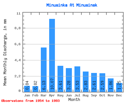
| Statistic | Jan | Feb | Mar | Apr | May | Jun | Jul | Aug | Sep | Oct | Nov | Dec | Annual |
|---|---|---|---|---|---|---|---|---|---|---|---|---|---|
| Mean | 0.84 | 0.83 | 6.13 | 10.07 | 3.60 | 3.28 | 3.54 | 2.83 | 2.61 | 2.59 | 1.85 | 1.25 | 36.04 |
| Standard Deviation | 0.69 | 0.71 | 6.57 | 8.67 | 1.81 | 1.09 | 2.25 | 1.13 | 0.75 | 0.59 | 0.93 | 0.87 | 10.23 |
| Min | 0.00 | 0.00 | 0.47 | 3.24 | 2.28 | 1.44 | 1.49 | 1.49 | 1.38 | 1.52 | 0.62 | 0.01 | 21.35 |
| Max | 2.59 | 2.50 | 32.71 | 42.86 | 12.93 | 6.48 | 13.24 | 7.30 | 4.56 | 4.11 | 5.60 | 4.26 | 68.13 |
| Coefficient of Variation | 0.82 | 0.86 | 1.07 | 0.86 | 0.50 | 0.33 | 0.64 | 0.40 | 0.29 | 0.23 | 0.50 | 0.70 | 0.28 |
 Return to R-Arctic Net Home Page