|
|
|||||||||||||||||
| Point ID: 655 | Downloads | Plots | Site Data | Other Close Sites | Code: 07BC001 |
|
|
|||||||||||||||||
| Download | |
|---|---|
| Site Descriptor Information | Site Time Series Data |
| Link to all available data | |
| View: | Time Series | All |
| Units: | mm |
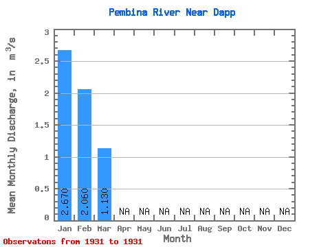
| Statistic | Jan | Feb | Mar | Apr | May | Jun | Jul | Aug | Sep | Oct | Nov | Dec | Annual |
|---|---|---|---|---|---|---|---|---|---|---|---|---|---|
| Mean | 2.67 | 2.06 | 1.13 | ||||||||||
| Standard Deviation | |||||||||||||
| Min | 2.67 | 2.06 | 1.13 | ||||||||||
| Max | 2.67 | 2.06 | 1.13 | ||||||||||
| Coefficient of Variation |
| Other Close Sites | ||||||
|---|---|---|---|---|---|---|
| PointID | Latitude | Longitude | Drainage Area | Source | Name | |
| 656 | "PEMBINA RIVER AT JARVIE" | 54.45 | 1581591 | Hydat | ||
 Return to R-Arctic Net Home Page