|
|
|||||||||||||||||
| Point ID: 656 | Downloads | Plots | Site Data | Other Close Sites | Code: 07BC002 |
|
|
|||||||||||||||||
| Download | |
|---|---|
| Site Descriptor Information | Site Time Series Data |
| Link to all available data | |
| View: | Time Series | All |
| Units: | mm |
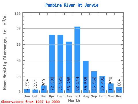
| Statistic | Jan | Feb | Mar | Apr | May | Jun | Jul | Aug | Sep | Oct | Nov | Dec | Annual |
|---|---|---|---|---|---|---|---|---|---|---|---|---|---|
| Mean | 4.95 | 4.29 | 9.20 | 72.39 | 71.92 | 63.80 | 82.24 | 39.53 | 26.56 | 20.50 | 11.52 | 6.88 | 36.04 |
| Standard Deviation | 2.40 | 1.84 | 8.62 | 55.98 | 51.28 | 48.69 | 70.83 | 35.87 | 19.91 | 14.24 | 6.12 | 3.90 | 16.90 |
| Min | 0.69 | 0.86 | 1.64 | 9.07 | 10.20 | 15.10 | 8.48 | 4.49 | 4.16 | 4.60 | 2.28 | 0.86 | 13.64 |
| Max | 11.80 | 8.39 | 37.70 | 309.00 | 289.00 | 237.00 | 321.00 | 217.00 | 95.40 | 63.90 | 27.40 | 16.30 | 84.56 |
| Coefficient of Variation | 0.48 | 0.43 | 0.94 | 0.77 | 0.71 | 0.76 | 0.86 | 0.91 | 0.75 | 0.69 | 0.53 | 0.57 | 0.47 |
| Other Close Sites | ||||||
|---|---|---|---|---|---|---|
| PointID | Latitude | Longitude | Drainage Area | Source | Name | |
| 655 | "PEMBINA RIVER NEAR DAPP" | 54.35 | 1587140 | Hydat | ||
 Return to R-Arctic Net Home Page