|
|
|||||||||||||||||
| Point ID: 654 | Downloads | Plots | Site Data | Code: 07BB903 |
|
|
|||||||||||||||||
| Download | |
|---|---|
| Site Descriptor Information | Site Time Series Data |
| Link to all available data | |
| View: | Time Series | All |
| Units: | mm |
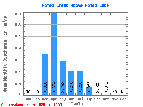
| Statistic | Jan | Feb | Mar | Apr | May | Jun | Jul | Aug | Sep | Oct | Nov | Dec | Annual |
|---|---|---|---|---|---|---|---|---|---|---|---|---|---|
| Mean | 0.36 | 0.69 | 0.29 | 0.21 | 0.21 | 0.07 | 0.01 | 0.00 | |||||
| Standard Deviation | 0.46 | 0.76 | 0.48 | 0.34 | 0.35 | 0.24 | 0.01 | 0.01 | |||||
| Min | 0.00 | 0.01 | 0.00 | 0.00 | 0.00 | 0.00 | 0.00 | 0.00 | |||||
| Max | 1.36 | 2.91 | 1.62 | 1.10 | 1.39 | 0.99 | 0.04 | 0.03 | |||||
| Coefficient of Variation | 1.29 | 1.09 | 1.64 | 1.66 | 1.68 | 3.46 | 2.42 | 3.70 |
 Return to R-Arctic Net Home Page