|
|
|||||||||||||||||
| Point ID: 654 | Downloads | Plots | Site Data | Code: 07BB903 |
|
|
|||||||||||||||||
| Download | |
|---|---|
| Site Descriptor Information | Site Time Series Data |
| Link to all available data | |
| View: | Time Series | All |
| Units: | m3/s |
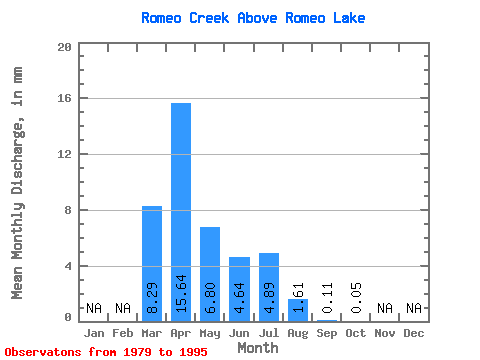
| Statistic | Jan | Feb | Mar | Apr | May | Jun | Jul | Aug | Sep | Oct | Nov | Dec | Annual |
|---|---|---|---|---|---|---|---|---|---|---|---|---|---|
| Mean | 8.29 | 15.65 | 6.80 | 4.65 | 4.88 | 1.61 | 0.10 | 0.04 | |||||
| Standard Deviation | 10.66 | 17.10 | 11.16 | 7.69 | 8.19 | 5.57 | 0.25 | 0.15 | |||||
| Min | 0.00 | 0.11 | 0.00 | 0.00 | 0.00 | 0.00 | 0.00 | 0.00 | |||||
| Max | 31.67 | 65.59 | 37.73 | 24.79 | 32.37 | 23.05 | 0.95 | 0.60 | |||||
| Coefficient of Variation | 1.29 | 1.09 | 1.64 | 1.66 | 1.68 | 3.46 | 2.42 | 3.70 |
 Return to R-Arctic Net Home Page