|
|
|||||||||||||||||
| Point ID: 6533 | Downloads | Plots | Site Data | Code: 8381 |
|
|
|||||||||||||||||
| Download | |
|---|---|
| Site Descriptor Information | Site Time Series Data |
| Link to all available data | |
| View: | Time Series | All |
| Units: | mm |
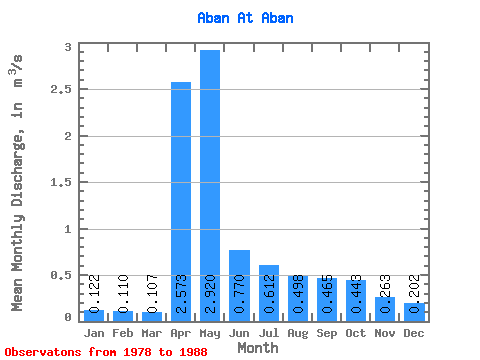
| Statistic | Jan | Feb | Mar | Apr | May | Jun | Jul | Aug | Sep | Oct | Nov | Dec | Annual |
|---|---|---|---|---|---|---|---|---|---|---|---|---|---|
| Mean | 0.12 | 0.11 | 0.11 | 2.57 | 2.92 | 0.77 | 0.61 | 0.50 | 0.47 | 0.44 | 0.26 | 0.20 | 0.80 |
| Standard Deviation | 0.07 | 0.06 | 0.06 | 1.67 | 1.64 | 0.37 | 0.39 | 0.38 | 0.21 | 0.17 | 0.10 | 0.08 | 0.23 |
| Min | 0.01 | 0.01 | 0.01 | 0.49 | 1.33 | 0.25 | 0.11 | 0.11 | 0.13 | 0.15 | 0.13 | 0.08 | 0.59 |
| Max | 0.23 | 0.18 | 0.17 | 5.75 | 7.19 | 1.57 | 1.59 | 1.37 | 0.93 | 0.70 | 0.47 | 0.34 | 1.32 |
| Coefficient of Variation | 0.61 | 0.50 | 0.56 | 0.65 | 0.56 | 0.48 | 0.63 | 0.76 | 0.45 | 0.39 | 0.37 | 0.38 | 0.29 |
 Return to R-Arctic Net Home Page