|
|
|||||||||||||||||
| Point ID: 6533 | Downloads | Plots | Site Data | Code: 8381 |
|
|
|||||||||||||||||
| Download | |
|---|---|
| Site Descriptor Information | Site Time Series Data |
| Link to all available data | |
| View: | Time Series | All |
| Units: | m3/s |
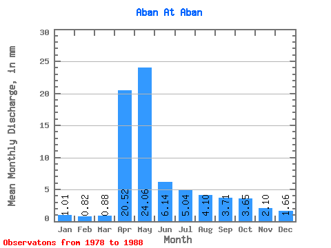
| Statistic | Jan | Feb | Mar | Apr | May | Jun | Jul | Aug | Sep | Oct | Nov | Dec | Annual |
|---|---|---|---|---|---|---|---|---|---|---|---|---|---|
| Mean | 1.00 | 0.82 | 0.88 | 20.52 | 24.06 | 6.14 | 5.04 | 4.11 | 3.71 | 3.65 | 2.10 | 1.67 | 77.22 |
| Standard Deviation | 0.61 | 0.41 | 0.49 | 13.32 | 13.50 | 2.98 | 3.19 | 3.13 | 1.67 | 1.41 | 0.78 | 0.63 | 22.58 |
| Min | 0.12 | 0.07 | 0.08 | 3.91 | 10.96 | 1.99 | 0.91 | 0.91 | 1.04 | 1.24 | 1.04 | 0.63 | 57.22 |
| Max | 1.90 | 1.35 | 1.40 | 45.86 | 59.25 | 12.52 | 13.10 | 11.29 | 7.42 | 5.77 | 3.75 | 2.80 | 127.94 |
| Coefficient of Variation | 0.61 | 0.50 | 0.56 | 0.65 | 0.56 | 0.48 | 0.63 | 0.76 | 0.45 | 0.39 | 0.37 | 0.38 | 0.29 |
 Return to R-Arctic Net Home Page