|
|
|||||||||||||||||
| Point ID: 6515 | Downloads | Plots | Site Data | Code: 8339 |
|
|
|||||||||||||||||
| Download | |
|---|---|
| Site Descriptor Information | Site Time Series Data |
| Link to all available data | |
| View: | Time Series | All |
| Units: | mm |
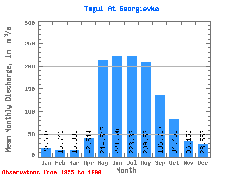
| Statistic | Jan | Feb | Mar | Apr | May | Jun | Jul | Aug | Sep | Oct | Nov | Dec | Annual |
|---|---|---|---|---|---|---|---|---|---|---|---|---|---|
| Mean | 20.64 | 15.75 | 15.89 | 42.51 | 214.52 | 221.55 | 223.37 | 209.57 | 136.72 | 84.45 | 36.16 | 28.55 | 104.03 |
| Standard Deviation | 4.34 | 4.35 | 5.76 | 28.18 | 70.02 | 86.44 | 80.59 | 81.43 | 35.24 | 24.34 | 9.15 | 6.22 | 18.25 |
| Min | 12.20 | 8.49 | 6.97 | 16.20 | 34.30 | 98.10 | 95.00 | 85.00 | 72.80 | 55.20 | 19.70 | 16.30 | 67.08 |
| Max | 29.90 | 27.20 | 34.80 | 159.00 | 348.00 | 501.00 | 452.00 | 505.00 | 208.00 | 152.00 | 54.50 | 48.70 | 134.17 |
| Coefficient of Variation | 0.21 | 0.28 | 0.36 | 0.66 | 0.33 | 0.39 | 0.36 | 0.39 | 0.26 | 0.29 | 0.25 | 0.22 | 0.17 |
 Return to R-Arctic Net Home Page