|
|
|||||||||||||||||
| Point ID: 6515 | Downloads | Plots | Site Data | Code: 8339 |
|
|
|||||||||||||||||
| Download | |
|---|---|
| Site Descriptor Information | Site Time Series Data |
| Link to all available data | |
| View: | Time Series | All |
| Units: | m3/s |
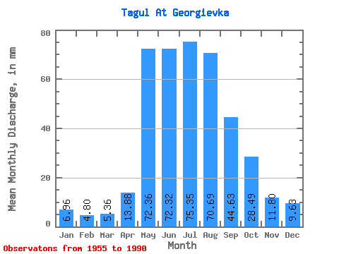
| Statistic | Jan | Feb | Mar | Apr | May | Jun | Jul | Aug | Sep | Oct | Nov | Dec | Annual |
|---|---|---|---|---|---|---|---|---|---|---|---|---|---|
| Mean | 6.96 | 4.84 | 5.36 | 13.88 | 72.35 | 72.32 | 75.34 | 70.68 | 44.63 | 28.48 | 11.80 | 9.63 | 413.51 |
| Standard Deviation | 1.46 | 1.34 | 1.94 | 9.20 | 23.62 | 28.22 | 27.18 | 27.46 | 11.50 | 8.21 | 2.99 | 2.10 | 72.55 |
| Min | 4.12 | 2.61 | 2.35 | 5.29 | 11.57 | 32.02 | 32.04 | 28.67 | 23.77 | 18.62 | 6.43 | 5.50 | 266.61 |
| Max | 10.09 | 8.36 | 11.74 | 51.91 | 117.37 | 163.55 | 152.45 | 170.33 | 67.90 | 51.27 | 17.79 | 16.43 | 533.29 |
| Coefficient of Variation | 0.21 | 0.28 | 0.36 | 0.66 | 0.33 | 0.39 | 0.36 | 0.39 | 0.26 | 0.29 | 0.25 | 0.22 | 0.17 |
 Return to R-Arctic Net Home Page