|
|
|||||||||||||||||
| Point ID: 6512 | Downloads | Plots | Site Data | Code: 8331 |
|
|
|||||||||||||||||
| Download | |
|---|---|
| Site Descriptor Information | Site Time Series Data |
| Link to all available data | |
| View: | Time Series | All |
| Units: | mm |
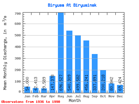
| Statistic | Jan | Feb | Mar | Apr | May | Jun | Jul | Aug | Sep | Oct | Nov | Dec | Annual |
|---|---|---|---|---|---|---|---|---|---|---|---|---|---|
| Mean | 54.00 | 42.41 | 39.59 | 147.38 | 696.53 | 540.31 | 499.58 | 456.24 | 337.89 | 200.22 | 80.84 | 69.42 | 263.21 |
| Standard Deviation | 10.57 | 8.03 | 7.34 | 112.11 | 221.69 | 199.31 | 196.18 | 161.91 | 131.29 | 64.72 | 24.14 | 15.03 | 54.54 |
| Min | 30.00 | 25.90 | 23.70 | 40.20 | 289.00 | 221.00 | 208.00 | 151.00 | 150.00 | 118.00 | 39.40 | 39.00 | 146.07 |
| Max | 78.00 | 64.00 | 59.20 | 543.00 | 1330.00 | 1110.00 | 994.00 | 877.00 | 1010.00 | 417.00 | 150.00 | 104.00 | 368.90 |
| Coefficient of Variation | 0.20 | 0.19 | 0.18 | 0.76 | 0.32 | 0.37 | 0.39 | 0.35 | 0.39 | 0.32 | 0.30 | 0.22 | 0.21 |
 Return to R-Arctic Net Home Page