|
|
|||||||||||||||||
| Point ID: 6512 | Downloads | Plots | Site Data | Code: 8331 |
|
|
|||||||||||||||||
| Download | |
|---|---|
| Site Descriptor Information | Site Time Series Data |
| Link to all available data | |
| View: | Time Series | All |
| Units: | m3/s |
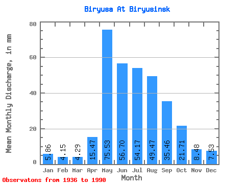
| Statistic | Jan | Feb | Mar | Apr | May | Jun | Jul | Aug | Sep | Oct | Nov | Dec | Annual |
|---|---|---|---|---|---|---|---|---|---|---|---|---|---|
| Mean | 5.86 | 4.19 | 4.29 | 15.47 | 75.52 | 56.70 | 54.16 | 49.47 | 35.46 | 21.71 | 8.48 | 7.53 | 336.31 |
| Standard Deviation | 1.15 | 0.79 | 0.80 | 11.76 | 24.04 | 20.92 | 21.27 | 17.55 | 13.78 | 7.02 | 2.53 | 1.63 | 69.69 |
| Min | 3.25 | 2.56 | 2.57 | 4.22 | 31.33 | 23.19 | 22.55 | 16.37 | 15.74 | 12.79 | 4.13 | 4.23 | 186.65 |
| Max | 8.46 | 6.32 | 6.42 | 56.98 | 144.20 | 116.48 | 107.77 | 95.08 | 105.99 | 45.21 | 15.74 | 11.28 | 471.36 |
| Coefficient of Variation | 0.20 | 0.19 | 0.18 | 0.76 | 0.32 | 0.37 | 0.39 | 0.35 | 0.39 | 0.32 | 0.30 | 0.22 | 0.21 |
 Return to R-Arctic Net Home Page