|
|
|||||||||||||||||
| Point ID: 6499 | Downloads | Plots | Site Data | Code: 8292 |
|
|
|||||||||||||||||
| Download | |
|---|---|
| Site Descriptor Information | Site Time Series Data |
| Link to all available data | |
| View: | Time Series | All |
| Units: | mm |
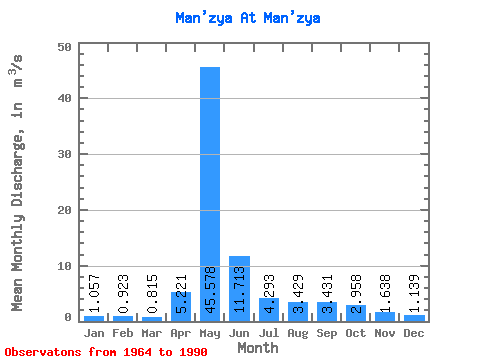
| Statistic | Jan | Feb | Mar | Apr | May | Jun | Jul | Aug | Sep | Oct | Nov | Dec | Annual |
|---|---|---|---|---|---|---|---|---|---|---|---|---|---|
| Mean | 1.06 | 0.92 | 0.81 | 5.22 | 45.58 | 11.71 | 4.29 | 3.43 | 3.43 | 2.96 | 1.64 | 1.14 | 6.86 |
| Standard Deviation | 0.81 | 0.58 | 0.61 | 6.98 | 14.11 | 6.45 | 2.46 | 1.62 | 1.75 | 1.14 | 0.61 | 0.67 | 1.68 |
| Min | 0.21 | 0.19 | 0.16 | 0.16 | 10.80 | 3.66 | 0.83 | 1.03 | 1.43 | 1.38 | 0.56 | 0.21 | 2.38 |
| Max | 4.20 | 2.57 | 2.61 | 24.90 | 77.60 | 27.50 | 10.50 | 8.56 | 8.74 | 5.56 | 2.96 | 3.08 | 9.44 |
| Coefficient of Variation | 0.77 | 0.63 | 0.76 | 1.34 | 0.31 | 0.55 | 0.57 | 0.47 | 0.51 | 0.39 | 0.37 | 0.59 | 0.24 |
 Return to R-Arctic Net Home Page