|
|
|||||||||||||||||
| Point ID: 6499 | Downloads | Plots | Site Data | Code: 8292 |
|
|
|||||||||||||||||
| Download | |
|---|---|
| Site Descriptor Information | Site Time Series Data |
| Link to all available data | |
| View: | Time Series | All |
| Units: | m3/s |
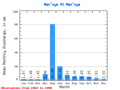
| Statistic | Jan | Feb | Mar | Apr | May | Jun | Jul | Aug | Sep | Oct | Nov | Dec | Annual |
|---|---|---|---|---|---|---|---|---|---|---|---|---|---|
| Mean | 1.88 | 1.49 | 1.45 | 8.96 | 80.83 | 20.11 | 7.61 | 6.08 | 5.89 | 5.25 | 2.81 | 2.02 | 143.34 |
| Standard Deviation | 1.44 | 0.94 | 1.09 | 11.98 | 25.03 | 11.07 | 4.35 | 2.87 | 3.00 | 2.02 | 1.04 | 1.19 | 35.07 |
| Min | 0.37 | 0.31 | 0.28 | 0.28 | 19.15 | 6.28 | 1.47 | 1.83 | 2.46 | 2.45 | 0.96 | 0.37 | 49.69 |
| Max | 7.45 | 4.15 | 4.63 | 42.74 | 137.62 | 47.20 | 18.62 | 15.18 | 15.00 | 9.86 | 5.08 | 5.46 | 197.28 |
| Coefficient of Variation | 0.77 | 0.63 | 0.76 | 1.34 | 0.31 | 0.55 | 0.57 | 0.47 | 0.51 | 0.39 | 0.37 | 0.59 | 0.24 |
 Return to R-Arctic Net Home Page