|
|
|||||||||||||||||
| Point ID: 6496 | Downloads | Plots | Site Data | Code: 8289 |
|
|
|||||||||||||||||
| Download | |
|---|---|
| Site Descriptor Information | Site Time Series Data |
| Link to all available data | |
| View: | Time Series | All |
| Units: | mm |
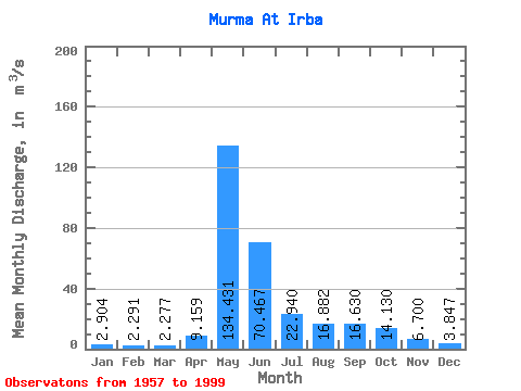
| Statistic | Jan | Feb | Mar | Apr | May | Jun | Jul | Aug | Sep | Oct | Nov | Dec | Annual |
|---|---|---|---|---|---|---|---|---|---|---|---|---|---|
| Mean | 2.90 | 2.29 | 2.28 | 9.16 | 134.43 | 70.47 | 22.94 | 16.88 | 16.63 | 14.13 | 6.70 | 3.85 | 25.22 |
| Standard Deviation | 1.24 | 1.05 | 1.11 | 12.01 | 47.06 | 100.58 | 13.69 | 8.30 | 6.94 | 4.62 | 2.79 | 1.89 | 10.29 |
| Min | 1.10 | 0.88 | 0.73 | 1.39 | 29.50 | 11.40 | 10.70 | 8.59 | 9.21 | 6.52 | 2.62 | 1.34 | 11.58 |
| Max | 6.48 | 4.52 | 4.86 | 72.40 | 256.00 | 629.00 | 81.80 | 49.10 | 38.10 | 22.90 | 16.70 | 11.50 | 74.47 |
| Coefficient of Variation | 0.43 | 0.46 | 0.49 | 1.31 | 0.35 | 1.43 | 0.60 | 0.49 | 0.42 | 0.33 | 0.42 | 0.49 | 0.41 |
 Return to R-Arctic Net Home Page