|
|
|||||||||||||||||
| Point ID: 6496 | Downloads | Plots | Site Data | Code: 8289 |
|
|
|||||||||||||||||
| Download | |
|---|---|
| Site Descriptor Information | Site Time Series Data |
| Link to all available data | |
| View: | Time Series | All |
| Units: | m3/s |
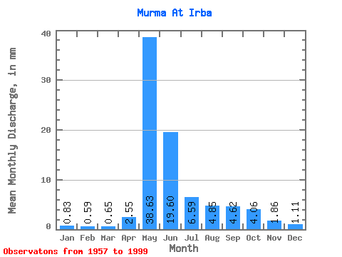
| Statistic | Jan | Feb | Mar | Apr | May | Jun | Jul | Aug | Sep | Oct | Nov | Dec | Annual |
|---|---|---|---|---|---|---|---|---|---|---|---|---|---|
| Mean | 0.83 | 0.60 | 0.65 | 2.55 | 38.63 | 19.60 | 6.59 | 4.85 | 4.62 | 4.06 | 1.86 | 1.11 | 85.42 |
| Standard Deviation | 0.36 | 0.27 | 0.32 | 3.34 | 13.52 | 27.97 | 3.93 | 2.38 | 1.93 | 1.33 | 0.78 | 0.54 | 34.84 |
| Min | 0.32 | 0.23 | 0.21 | 0.39 | 8.48 | 3.17 | 3.08 | 2.47 | 2.56 | 1.87 | 0.73 | 0.39 | 39.22 |
| Max | 1.86 | 1.18 | 1.40 | 20.14 | 73.56 | 174.93 | 23.50 | 14.11 | 10.60 | 6.58 | 4.64 | 3.30 | 252.17 |
| Coefficient of Variation | 0.43 | 0.46 | 0.49 | 1.31 | 0.35 | 1.43 | 0.60 | 0.49 | 0.42 | 0.33 | 0.42 | 0.49 | 0.41 |
 Return to R-Arctic Net Home Page