|
|
|||||||||||||||||
| Point ID: 6487 | Downloads | Plots | Site Data | Code: 8246 |
|
|
|||||||||||||||||
| Download | |
|---|---|
| Site Descriptor Information | Site Time Series Data |
| Link to all available data | |
| View: | Time Series | All |
| Units: | mm |
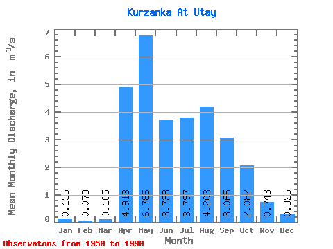
| Statistic | Jan | Feb | Mar | Apr | May | Jun | Jul | Aug | Sep | Oct | Nov | Dec | Annual |
|---|---|---|---|---|---|---|---|---|---|---|---|---|---|
| Mean | 0.14 | 0.07 | 0.10 | 4.91 | 6.79 | 3.74 | 3.80 | 4.20 | 3.06 | 2.08 | 0.74 | 0.33 | 2.49 |
| Standard Deviation | 0.10 | 0.09 | 0.16 | 2.93 | 4.36 | 2.21 | 2.31 | 3.30 | 2.25 | 0.93 | 0.32 | 0.17 | 0.92 |
| Min | 0.00 | 0.00 | 0.00 | 0.90 | 1.12 | 1.51 | 0.91 | 0.76 | 0.93 | 0.72 | 0.20 | 0.03 | 1.13 |
| Max | 0.37 | 0.28 | 0.66 | 12.80 | 20.30 | 10.80 | 9.07 | 12.60 | 11.30 | 4.44 | 1.50 | 0.78 | 4.61 |
| Coefficient of Variation | 0.76 | 1.20 | 1.49 | 0.60 | 0.64 | 0.59 | 0.61 | 0.79 | 0.73 | 0.45 | 0.43 | 0.53 | 0.37 |
 Return to R-Arctic Net Home Page