|
|
|||||||||||||||||
| Point ID: 6487 | Downloads | Plots | Site Data | Code: 8246 |
|
|
|||||||||||||||||
| Download | |
|---|---|
| Site Descriptor Information | Site Time Series Data |
| Link to all available data | |
| View: | Time Series | All |
| Units: | m3/s |
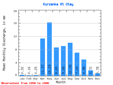
| Statistic | Jan | Feb | Mar | Apr | May | Jun | Jul | Aug | Sep | Oct | Nov | Dec | Annual |
|---|---|---|---|---|---|---|---|---|---|---|---|---|---|
| Mean | 0.32 | 0.16 | 0.25 | 11.37 | 16.22 | 8.65 | 9.08 | 10.05 | 7.09 | 4.98 | 1.72 | 0.78 | 70.08 |
| Standard Deviation | 0.25 | 0.19 | 0.37 | 6.77 | 10.43 | 5.11 | 5.52 | 7.88 | 5.20 | 2.23 | 0.74 | 0.41 | 25.83 |
| Min | 0.00 | 0.00 | 0.00 | 2.08 | 2.68 | 3.50 | 2.18 | 1.82 | 2.15 | 1.72 | 0.46 | 0.07 | 31.86 |
| Max | 0.89 | 0.61 | 1.58 | 29.62 | 48.54 | 24.99 | 21.69 | 30.13 | 26.15 | 10.62 | 3.47 | 1.86 | 129.83 |
| Coefficient of Variation | 0.76 | 1.20 | 1.49 | 0.60 | 0.64 | 0.59 | 0.61 | 0.79 | 0.73 | 0.45 | 0.43 | 0.53 | 0.37 |
 Return to R-Arctic Net Home Page