|
|
|||||||||||||||||
| Point ID: 6480 | Downloads | Plots | Site Data | Code: 8209 |
|
|
|||||||||||||||||
| Download | |
|---|---|
| Site Descriptor Information | Site Time Series Data |
| Link to all available data | |
| View: | Time Series | All |
| Units: | mm |
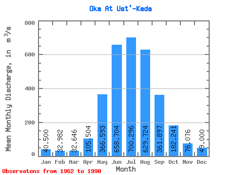
| Statistic | Jan | Feb | Mar | Apr | May | Jun | Jul | Aug | Sep | Oct | Nov | Dec | Annual |
|---|---|---|---|---|---|---|---|---|---|---|---|---|---|
| Mean | 40.50 | 32.98 | 32.65 | 105.50 | 366.59 | 658.70 | 700.30 | 629.72 | 361.90 | 182.24 | 76.08 | 49.00 | 270.06 |
| Standard Deviation | 10.31 | 7.70 | 6.11 | 49.93 | 107.05 | 148.46 | 207.99 | 224.76 | 86.05 | 41.16 | 19.71 | 14.32 | 42.12 |
| Min | 21.10 | 19.10 | 20.50 | 39.00 | 213.00 | 374.00 | 379.00 | 397.00 | 228.00 | 119.00 | 45.10 | 20.40 | 196.79 |
| Max | 73.10 | 50.80 | 43.90 | 221.00 | 583.00 | 1110.00 | 1340.00 | 1320.00 | 638.00 | 315.00 | 121.00 | 85.40 | 355.07 |
| Coefficient of Variation | 0.26 | 0.23 | 0.19 | 0.47 | 0.29 | 0.23 | 0.30 | 0.36 | 0.24 | 0.23 | 0.26 | 0.29 | 0.16 |
 Return to R-Arctic Net Home Page