|
|
|||||||||||||||||
| Point ID: 6480 | Downloads | Plots | Site Data | Code: 8209 |
|
|
|||||||||||||||||
| Download | |
|---|---|
| Site Descriptor Information | Site Time Series Data |
| Link to all available data | |
| View: | Time Series | All |
| Units: | m3/s |
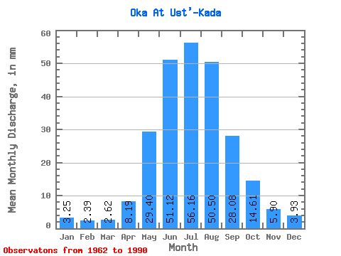
| Statistic | Jan | Feb | Mar | Apr | May | Jun | Jul | Aug | Sep | Oct | Nov | Dec | Annual |
|---|---|---|---|---|---|---|---|---|---|---|---|---|---|
| Mean | 3.25 | 2.41 | 2.62 | 8.19 | 29.39 | 51.12 | 56.15 | 50.49 | 28.09 | 14.61 | 5.90 | 3.93 | 255.18 |
| Standard Deviation | 0.83 | 0.56 | 0.49 | 3.88 | 8.58 | 11.52 | 16.68 | 18.02 | 6.68 | 3.30 | 1.53 | 1.15 | 39.80 |
| Min | 1.69 | 1.40 | 1.64 | 3.03 | 17.08 | 29.02 | 30.39 | 31.83 | 17.69 | 9.54 | 3.50 | 1.64 | 185.95 |
| Max | 5.86 | 3.71 | 3.52 | 17.15 | 46.74 | 86.14 | 107.44 | 105.84 | 49.51 | 25.26 | 9.39 | 6.85 | 335.51 |
| Coefficient of Variation | 0.26 | 0.23 | 0.19 | 0.47 | 0.29 | 0.23 | 0.30 | 0.36 | 0.24 | 0.23 | 0.26 | 0.29 | 0.16 |
 Return to R-Arctic Net Home Page