|
|
|||||||||||||||||
| Point ID: 6479 | Downloads | Plots | Site Data | Code: 8207 |
|
|
|||||||||||||||||
| Download | |
|---|---|
| Site Descriptor Information | Site Time Series Data |
| Link to all available data | |
| View: | Time Series | All |
| Units: | mm |
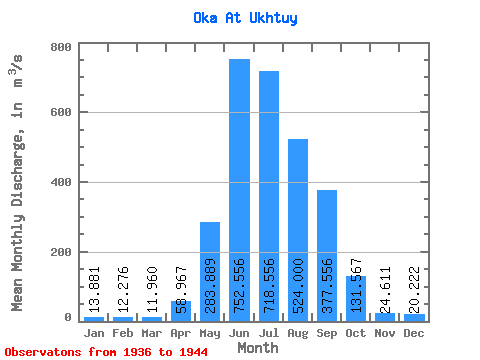
| Statistic | Jan | Feb | Mar | Apr | May | Jun | Jul | Aug | Sep | Oct | Nov | Dec | Annual |
|---|---|---|---|---|---|---|---|---|---|---|---|---|---|
| Mean | 13.88 | 12.28 | 11.96 | 58.97 | 283.89 | 752.56 | 718.56 | 524.00 | 377.56 | 131.57 | 24.61 | 20.22 | 244.17 |
| Standard Deviation | 7.09 | 6.52 | 6.37 | 44.31 | 96.84 | 180.08 | 178.37 | 130.40 | 169.33 | 49.47 | 14.95 | 10.34 | 35.77 |
| Min | 3.30 | 2.70 | 2.70 | 4.20 | 136.00 | 524.00 | 481.00 | 336.00 | 247.00 | 78.40 | 12.00 | 6.00 | 197.29 |
| Max | 22.40 | 20.40 | 20.00 | 118.00 | 398.00 | 1060.00 | 1000.00 | 768.00 | 800.00 | 232.00 | 53.30 | 33.60 | 290.44 |
| Coefficient of Variation | 0.51 | 0.53 | 0.53 | 0.75 | 0.34 | 0.24 | 0.25 | 0.25 | 0.45 | 0.38 | 0.61 | 0.51 | 0.15 |
 Return to R-Arctic Net Home Page