|
|
|||||||||||||||||
| Point ID: 6479 | Downloads | Plots | Site Data | Code: 8207 |
|
|
|||||||||||||||||
| Download | |
|---|---|
| Site Descriptor Information | Site Time Series Data |
| Link to all available data | |
| View: | Time Series | All |
| Units: | m3/s |
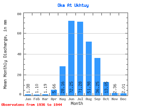
| Statistic | Jan | Feb | Mar | Apr | May | Jun | Jul | Aug | Sep | Oct | Nov | Dec | Annual |
|---|---|---|---|---|---|---|---|---|---|---|---|---|---|
| Mean | 1.38 | 1.11 | 1.19 | 5.66 | 28.16 | 72.25 | 71.27 | 51.97 | 36.24 | 13.05 | 2.36 | 2.01 | 285.41 |
| Standard Deviation | 0.70 | 0.59 | 0.63 | 4.25 | 9.61 | 17.29 | 17.69 | 12.93 | 16.26 | 4.91 | 1.44 | 1.03 | 41.82 |
| Min | 0.33 | 0.24 | 0.27 | 0.40 | 13.49 | 50.30 | 47.71 | 33.33 | 23.71 | 7.78 | 1.15 | 0.59 | 230.61 |
| Max | 2.22 | 1.84 | 1.98 | 11.33 | 39.48 | 101.76 | 99.19 | 76.17 | 76.80 | 23.01 | 5.12 | 3.33 | 339.49 |
| Coefficient of Variation | 0.51 | 0.53 | 0.53 | 0.75 | 0.34 | 0.24 | 0.25 | 0.25 | 0.45 | 0.38 | 0.61 | 0.51 | 0.15 |
 Return to R-Arctic Net Home Page