|
|
|||||||||||||||||
| Point ID: 6466 | Downloads | Plots | Site Data | Code: 8147 |
|
|
|||||||||||||||||
| Download | |
|---|---|
| Site Descriptor Information | Site Time Series Data |
| Link to all available data | |
| View: | Time Series | All |
| Units: | mm |
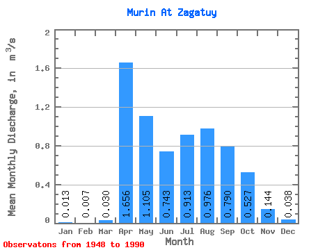
| Statistic | Jan | Feb | Mar | Apr | May | Jun | Jul | Aug | Sep | Oct | Nov | Dec | Annual |
|---|---|---|---|---|---|---|---|---|---|---|---|---|---|
| Mean | 0.01 | 0.01 | 0.03 | 1.66 | 1.10 | 0.74 | 0.91 | 0.98 | 0.79 | 0.53 | 0.14 | 0.04 | 0.56 |
| Standard Deviation | 0.04 | 0.03 | 0.10 | 1.25 | 1.05 | 0.80 | 0.88 | 0.91 | 0.78 | 0.44 | 0.20 | 0.08 | 0.36 |
| Min | 0.00 | 0.00 | 0.00 | 0.21 | 0.15 | 0.10 | 0.05 | 0.03 | 0.01 | 0.01 | 0.00 | 0.00 | 0.08 |
| Max | 0.17 | 0.14 | 0.50 | 5.07 | 4.95 | 4.19 | 4.28 | 4.07 | 3.68 | 1.78 | 0.74 | 0.34 | 1.44 |
| Coefficient of Variation | 3.08 | 4.19 | 3.46 | 0.76 | 0.95 | 1.07 | 0.96 | 0.93 | 0.98 | 0.84 | 1.35 | 2.17 | 0.65 |
 Return to R-Arctic Net Home Page