|
|
|||||||||||||||||
| Point ID: 6466 | Downloads | Plots | Site Data | Code: 8147 |
|
|
|||||||||||||||||
| Download | |
|---|---|
| Site Descriptor Information | Site Time Series Data |
| Link to all available data | |
| View: | Time Series | All |
| Units: | m3/s |
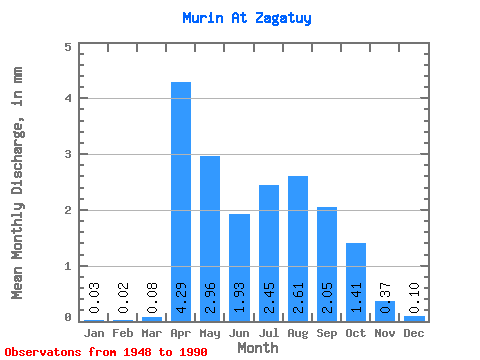
| Statistic | Jan | Feb | Mar | Apr | May | Jun | Jul | Aug | Sep | Oct | Nov | Dec | Annual |
|---|---|---|---|---|---|---|---|---|---|---|---|---|---|
| Mean | 0.04 | 0.02 | 0.08 | 4.29 | 2.96 | 1.93 | 2.44 | 2.61 | 2.05 | 1.41 | 0.37 | 0.10 | 17.81 |
| Standard Deviation | 0.11 | 0.07 | 0.28 | 3.24 | 2.81 | 2.06 | 2.34 | 2.42 | 2.01 | 1.18 | 0.51 | 0.22 | 11.50 |
| Min | 0.00 | 0.00 | 0.00 | 0.54 | 0.40 | 0.25 | 0.13 | 0.07 | 0.03 | 0.04 | 0.00 | 0.00 | 2.41 |
| Max | 0.46 | 0.34 | 1.34 | 13.14 | 13.26 | 10.86 | 11.46 | 10.90 | 9.54 | 4.77 | 1.92 | 0.91 | 45.49 |
| Coefficient of Variation | 3.08 | 4.19 | 3.46 | 0.76 | 0.95 | 1.07 | 0.96 | 0.93 | 0.98 | 0.84 | 1.35 | 2.17 | 0.65 |
 Return to R-Arctic Net Home Page