|
|
|||||||||||||||||
| Point ID: 645 | Downloads | Plots | Site Data | Code: 07BB002 |
|
|
|||||||||||||||||
| Download | |
|---|---|
| Site Descriptor Information | Site Time Series Data |
| Link to all available data | |
| View: | Time Series | All |
| Units: | mm |
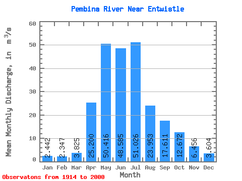
| Statistic | Jan | Feb | Mar | Apr | May | Jun | Jul | Aug | Sep | Oct | Nov | Dec | Annual |
|---|---|---|---|---|---|---|---|---|---|---|---|---|---|
| Mean | 2.44 | 2.35 | 3.83 | 25.20 | 50.42 | 48.59 | 51.03 | 23.95 | 17.61 | 12.67 | 6.46 | 3.60 | 20.60 |
| Standard Deviation | 1.07 | 1.04 | 2.66 | 16.07 | 36.57 | 40.26 | 47.49 | 24.56 | 14.46 | 8.83 | 3.39 | 1.86 | 8.75 |
| Min | 0.28 | 0.08 | 0.03 | 5.53 | 7.54 | 9.18 | 4.89 | 3.50 | 4.03 | 3.37 | 1.93 | 0.84 | 7.87 |
| Max | 5.33 | 4.37 | 15.20 | 79.80 | 194.00 | 210.00 | 229.00 | 141.00 | 65.40 | 45.60 | 15.70 | 8.10 | 42.19 |
| Coefficient of Variation | 0.44 | 0.44 | 0.69 | 0.64 | 0.72 | 0.83 | 0.93 | 1.02 | 0.82 | 0.70 | 0.53 | 0.52 | 0.42 |
 Return to R-Arctic Net Home Page