|
|
|||||||||||||||||
| Point ID: 645 | Downloads | Plots | Site Data | Code: 07BB002 |
|
|
|||||||||||||||||
| Download | |
|---|---|
| Site Descriptor Information | Site Time Series Data |
| Link to all available data | |
| View: | Time Series | All |
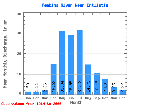
| Units: | m3/s |
| Statistic | Jan | Feb | Mar | Apr | May | Jun | Jul | Aug | Sep | Oct | Nov | Dec | Annual |
|---|---|---|---|---|---|---|---|---|---|---|---|---|---|
| Mean | 1.48 | 1.29 | 2.32 | 14.78 | 30.55 | 28.49 | 30.92 | 14.51 | 10.33 | 7.68 | 3.79 | 2.18 | 147.08 |
| Standard Deviation | 0.65 | 0.57 | 1.61 | 9.43 | 22.16 | 23.61 | 28.77 | 14.88 | 8.48 | 5.35 | 1.99 | 1.13 | 62.48 |
| Min | 0.17 | 0.04 | 0.02 | 3.24 | 4.57 | 5.38 | 2.96 | 2.12 | 2.36 | 2.04 | 1.13 | 0.51 | 56.18 |
| Max | 3.23 | 2.41 | 9.21 | 46.80 | 117.54 | 123.15 | 138.75 | 85.43 | 38.35 | 27.63 | 9.21 | 4.91 | 301.26 |
| Coefficient of Variation | 0.44 | 0.44 | 0.69 | 0.64 | 0.72 | 0.83 | 0.93 | 1.02 | 0.82 | 0.70 | 0.53 | 0.52 | 0.42 |
 Return to R-Arctic Net Home Page