|
|
|||||||||||||||||
| Point ID: 6448 | Downloads | Plots | Site Data | Code: 7167 |
|
|
|||||||||||||||||
| Download | |
|---|---|
| Site Descriptor Information | Site Time Series Data |
| Link to all available data | |
| View: | Time Series | All |
| Units: | mm |
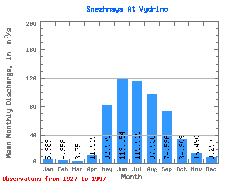
| Statistic | Jan | Feb | Mar | Apr | May | Jun | Jul | Aug | Sep | Oct | Nov | Dec | Annual |
|---|---|---|---|---|---|---|---|---|---|---|---|---|---|
| Mean | 5.99 | 4.36 | 3.75 | 11.52 | 82.97 | 119.15 | 115.92 | 97.94 | 74.54 | 34.31 | 15.49 | 9.30 | 47.77 |
| Standard Deviation | 1.55 | 1.02 | 0.75 | 6.38 | 22.89 | 54.06 | 59.58 | 37.80 | 27.24 | 9.64 | 4.47 | 2.29 | 10.51 |
| Min | 2.81 | 2.79 | 2.01 | 4.02 | 32.80 | 13.70 | 46.00 | 41.20 | 29.90 | 19.30 | 9.25 | 5.50 | 26.04 |
| Max | 11.90 | 9.14 | 6.27 | 28.30 | 136.00 | 313.00 | 349.00 | 242.00 | 174.00 | 68.30 | 40.00 | 16.10 | 73.14 |
| Coefficient of Variation | 0.26 | 0.23 | 0.20 | 0.55 | 0.28 | 0.45 | 0.51 | 0.39 | 0.36 | 0.28 | 0.29 | 0.25 | 0.22 |
 Return to R-Arctic Net Home Page