|
|
|||||||||||||||||
| Point ID: 6448 | Downloads | Plots | Site Data | Code: 7167 |
|
|
|||||||||||||||||
| Download | |
|---|---|
| Site Descriptor Information | Site Time Series Data |
| Link to all available data | |
| View: | Time Series | All |
| Units: | m3/s |
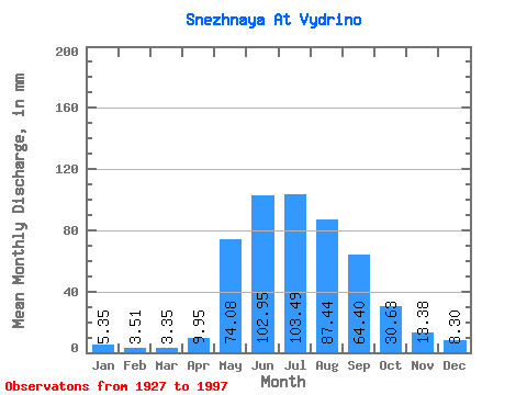
| Statistic | Jan | Feb | Mar | Apr | May | Jun | Jul | Aug | Sep | Oct | Nov | Dec | Annual |
|---|---|---|---|---|---|---|---|---|---|---|---|---|---|
| Mean | 5.35 | 3.54 | 3.35 | 9.95 | 74.07 | 102.95 | 103.47 | 87.43 | 64.40 | 30.63 | 13.38 | 8.30 | 502.52 |
| Standard Deviation | 1.38 | 0.83 | 0.67 | 5.51 | 20.44 | 46.71 | 53.18 | 33.74 | 23.54 | 8.61 | 3.87 | 2.04 | 110.61 |
| Min | 2.51 | 2.27 | 1.79 | 3.47 | 29.28 | 11.84 | 41.06 | 36.78 | 25.83 | 17.23 | 7.99 | 4.91 | 273.99 |
| Max | 10.62 | 7.43 | 5.60 | 24.45 | 121.40 | 270.43 | 311.54 | 216.03 | 150.34 | 60.97 | 34.56 | 14.37 | 769.42 |
| Coefficient of Variation | 0.26 | 0.23 | 0.20 | 0.55 | 0.28 | 0.45 | 0.51 | 0.39 | 0.36 | 0.28 | 0.29 | 0.25 | 0.22 |
 Return to R-Arctic Net Home Page