|
|
|||||||||||||||||
| Point ID: 644 | Downloads | Plots | Site Data | Code: 07BB001 |
|
|
|||||||||||||||||
| Download | |
|---|---|
| Site Descriptor Information | Site Time Series Data |
| Link to all available data | |
| View: | Time Series | All |
| Units: | mm |
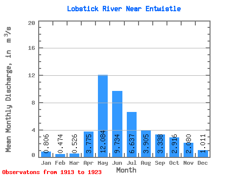
| Statistic | Jan | Feb | Mar | Apr | May | Jun | Jul | Aug | Sep | Oct | Nov | Dec | Annual |
|---|---|---|---|---|---|---|---|---|---|---|---|---|---|
| Mean | 0.81 | 0.47 | 0.53 | 3.77 | 12.08 | 9.73 | 6.64 | 3.91 | 3.34 | 2.92 | 2.08 | 1.01 | 3.81 |
| Standard Deviation | 0.63 | 0.54 | 0.50 | 2.35 | 12.58 | 8.45 | 4.89 | 2.63 | 2.11 | 1.57 | 1.24 | 0.61 | 2.18 |
| Min | 0.00 | 0.00 | 0.03 | 1.04 | 1.91 | 2.42 | 0.95 | 0.46 | 0.47 | 0.38 | 0.21 | 0.03 | 1.18 |
| Max | 1.76 | 1.59 | 1.18 | 8.33 | 37.00 | 25.40 | 16.10 | 9.32 | 7.35 | 5.73 | 4.25 | 1.75 | 7.16 |
| Coefficient of Variation | 0.78 | 1.13 | 0.94 | 0.62 | 1.04 | 0.87 | 0.74 | 0.67 | 0.63 | 0.54 | 0.59 | 0.61 | 0.57 |
 Return to R-Arctic Net Home Page