|
|
|||||||||||||||||
| Point ID: 644 | Downloads | Plots | Site Data | Code: 07BB001 |
|
|
|||||||||||||||||
| Download | |
|---|---|
| Site Descriptor Information | Site Time Series Data |
| Link to all available data | |
| View: | Time Series | All |
| Units: | m3/s |
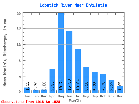
| Statistic | Jan | Feb | Mar | Apr | May | Jun | Jul | Aug | Sep | Oct | Nov | Dec | Annual |
|---|---|---|---|---|---|---|---|---|---|---|---|---|---|
| Mean | 1.31 | 0.70 | 0.85 | 5.93 | 19.61 | 15.29 | 10.77 | 6.34 | 5.24 | 4.73 | 3.27 | 1.64 | 72.97 |
| Standard Deviation | 1.02 | 0.79 | 0.81 | 3.70 | 20.41 | 13.27 | 7.94 | 4.27 | 3.31 | 2.55 | 1.94 | 1.00 | 41.73 |
| Min | 0.00 | 0.00 | 0.06 | 1.63 | 3.10 | 3.80 | 1.55 | 0.74 | 0.73 | 0.62 | 0.34 | 0.04 | 22.64 |
| Max | 2.86 | 2.35 | 1.92 | 13.09 | 60.05 | 39.90 | 26.13 | 15.13 | 11.55 | 9.30 | 6.68 | 2.84 | 136.93 |
| Coefficient of Variation | 0.78 | 1.13 | 0.94 | 0.62 | 1.04 | 0.87 | 0.74 | 0.67 | 0.63 | 0.54 | 0.59 | 0.61 | 0.57 |
 Return to R-Arctic Net Home Page