|
|
|||||||||||||||||
| Point ID: 643 | Downloads | Plots | Site Data | Code: 07BA003 |
|
|
|||||||||||||||||
| Download | |
|---|---|
| Site Descriptor Information | Site Time Series Data |
| Link to all available data | |
| View: | Time Series | All |
| Units: | mm |
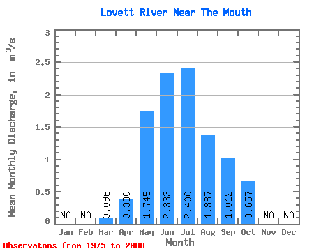
| Statistic | Jan | Feb | Mar | Apr | May | Jun | Jul | Aug | Sep | Oct | Nov | Dec | Annual |
|---|---|---|---|---|---|---|---|---|---|---|---|---|---|
| Mean | 0.10 | 0.38 | 1.75 | 2.33 | 2.40 | 1.39 | 1.01 | 0.66 | |||||
| Standard Deviation | 0.19 | 1.11 | 1.97 | 1.78 | 1.02 | 0.62 | 0.34 | ||||||
| Min | 0.10 | 0.21 | 0.46 | 0.64 | 0.53 | 0.28 | 0.32 | 0.23 | |||||
| Max | 0.10 | 0.59 | 5.61 | 10.50 | 6.92 | 4.59 | 2.49 | 1.56 | |||||
| Coefficient of Variation | 0.50 | 0.63 | 0.85 | 0.74 | 0.74 | 0.61 | 0.51 |
 Return to R-Arctic Net Home Page