|
|
|||||||||||||||||
| Point ID: 643 | Downloads | Plots | Site Data | Code: 07BA003 |
|
|
|||||||||||||||||
| Download | |
|---|---|
| Site Descriptor Information | Site Time Series Data |
| Link to all available data | |
| View: | Time Series | All |
| Units: | m3/s |
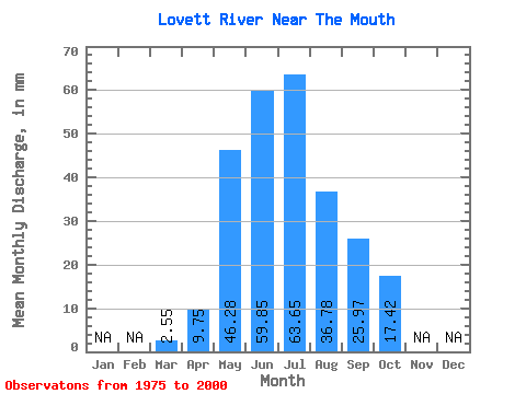
| Statistic | Jan | Feb | Mar | Apr | May | Jun | Jul | Aug | Sep | Oct | Nov | Dec | Annual |
|---|---|---|---|---|---|---|---|---|---|---|---|---|---|
| Mean | 2.54 | 9.76 | 46.27 | 59.84 | 63.63 | 36.79 | 25.98 | 17.41 | |||||
| Standard Deviation | 4.84 | 29.32 | 50.65 | 47.29 | 27.16 | 15.93 | 8.96 | ||||||
| Min | 2.54 | 5.52 | 12.06 | 16.37 | 14.00 | 7.50 | 8.31 | 5.99 | |||||
| Max | 2.54 | 15.04 | 148.75 | 269.46 | 183.48 | 121.70 | 63.90 | 41.36 | |||||
| Coefficient of Variation | 0.50 | 0.63 | 0.85 | 0.74 | 0.74 | 0.61 | 0.51 |
 Return to R-Arctic Net Home Page