|
|
|||||||||||||||||
| Point ID: 6424 | Downloads | Plots | Site Data | Code: 7091 |
|
|
|||||||||||||||||
| Download | |
|---|---|
| Site Descriptor Information | Site Time Series Data |
| Link to all available data | |
| View: | Time Series | All |
| Units: | mm |
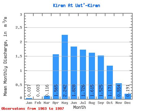
| Statistic | Jan | Feb | Mar | Apr | May | Jun | Jul | Aug | Sep | Oct | Nov | Dec | Annual |
|---|---|---|---|---|---|---|---|---|---|---|---|---|---|
| Mean | 0.04 | 0.00 | 0.12 | 1.56 | 2.24 | 1.83 | 1.73 | 1.61 | 1.52 | 1.17 | 0.55 | 0.19 | 1.15 |
| Standard Deviation | 0.06 | 0.01 | 0.13 | 0.51 | 0.66 | 1.13 | 0.80 | 0.96 | 0.75 | 0.45 | 0.20 | 0.13 | 0.32 |
| Min | 0.00 | 0.00 | 0.00 | 0.63 | 1.20 | 0.86 | 0.83 | 0.64 | 0.70 | 0.54 | 0.23 | 0.00 | 0.73 |
| Max | 0.30 | 0.02 | 0.48 | 2.72 | 4.14 | 7.00 | 3.99 | 5.85 | 4.42 | 2.75 | 1.06 | 0.53 | 1.75 |
| Coefficient of Variation | 1.63 | 2.17 | 1.13 | 0.33 | 0.29 | 0.62 | 0.47 | 0.60 | 0.49 | 0.38 | 0.36 | 0.66 | 0.28 |
 Return to R-Arctic Net Home Page