|
|
|||||||||||||||||
| Point ID: 6424 | Downloads | Plots | Site Data | Code: 7091 |
|
|
|||||||||||||||||
| Download | |
|---|---|
| Site Descriptor Information | Site Time Series Data |
| Link to all available data | |
| View: | Time Series | All |
| Units: | m3/s |
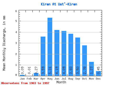
| Statistic | Jan | Feb | Mar | Apr | May | Jun | Jul | Aug | Sep | Oct | Nov | Dec | Annual |
|---|---|---|---|---|---|---|---|---|---|---|---|---|---|
| Mean | 0.09 | 0.01 | 0.28 | 3.59 | 5.31 | 4.19 | 4.09 | 3.83 | 3.50 | 2.78 | 1.27 | 0.45 | 32.20 |
| Standard Deviation | 0.14 | 0.01 | 0.31 | 1.17 | 1.55 | 2.58 | 1.91 | 2.28 | 1.71 | 1.06 | 0.46 | 0.30 | 9.00 |
| Min | 0.00 | 0.00 | 0.00 | 1.45 | 2.84 | 1.97 | 1.97 | 1.52 | 1.61 | 1.28 | 0.53 | 0.01 | 20.31 |
| Max | 0.71 | 0.04 | 1.14 | 6.24 | 9.81 | 16.06 | 9.46 | 13.86 | 10.14 | 6.52 | 2.43 | 1.26 | 48.99 |
| Coefficient of Variation | 1.63 | 2.17 | 1.13 | 0.33 | 0.29 | 0.62 | 0.47 | 0.60 | 0.49 | 0.38 | 0.36 | 0.66 | 0.28 |
 Return to R-Arctic Net Home Page