|
|
|||||||||||||||||
| Point ID: 6421 | Downloads | Plots | Site Data | Code: 7080 |
|
|
|||||||||||||||||
| Download | |
|---|---|
| Site Descriptor Information | Site Time Series Data |
| Link to all available data | |
| View: | Time Series | All |
| Units: | mm |
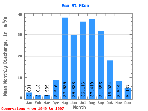
| Statistic | Jan | Feb | Mar | Apr | May | Jun | Jul | Aug | Sep | Oct | Nov | Dec | Annual |
|---|---|---|---|---|---|---|---|---|---|---|---|---|---|
| Mean | 3.03 | 2.01 | 1.94 | 8.92 | 37.93 | 29.84 | 36.12 | 37.42 | 31.66 | 18.03 | 8.51 | 5.14 | 18.38 |
| Standard Deviation | 1.29 | 1.02 | 0.97 | 5.67 | 13.61 | 16.14 | 16.59 | 19.50 | 15.24 | 6.81 | 2.57 | 1.76 | 5.33 |
| Min | 0.76 | 0.04 | 0.50 | 2.12 | 14.30 | 3.30 | 13.00 | 9.52 | 9.60 | 3.63 | 4.08 | 2.11 | 8.77 |
| Max | 5.92 | 4.66 | 4.66 | 21.80 | 79.50 | 74.50 | 85.60 | 94.00 | 81.70 | 32.10 | 16.50 | 9.56 | 31.50 |
| Coefficient of Variation | 0.43 | 0.51 | 0.50 | 0.64 | 0.36 | 0.54 | 0.46 | 0.52 | 0.48 | 0.38 | 0.30 | 0.34 | 0.29 |
 Return to R-Arctic Net Home Page