|
|
|||||||||||||||||
| Point ID: 6421 | Downloads | Plots | Site Data | Code: 7080 |
|
|
|||||||||||||||||
| Download | |
|---|---|
| Site Descriptor Information | Site Time Series Data |
| Link to all available data | |
| View: | Time Series | All |
| Units: | m3/s |
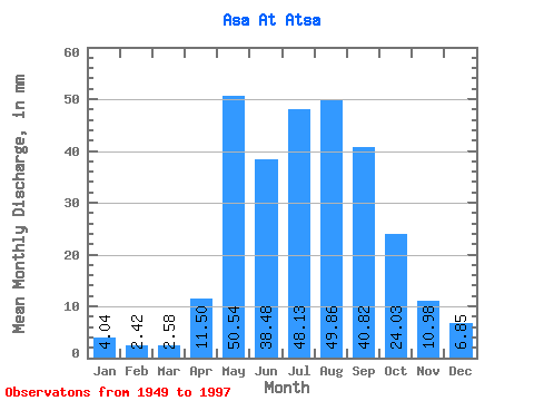
| Statistic | Jan | Feb | Mar | Apr | May | Jun | Jul | Aug | Sep | Oct | Nov | Dec | Annual |
|---|---|---|---|---|---|---|---|---|---|---|---|---|---|
| Mean | 4.04 | 2.44 | 2.58 | 11.50 | 50.53 | 38.48 | 48.12 | 49.85 | 40.82 | 24.03 | 10.98 | 6.84 | 288.62 |
| Standard Deviation | 1.72 | 1.24 | 1.29 | 7.31 | 18.13 | 20.82 | 22.11 | 25.98 | 19.65 | 9.07 | 3.31 | 2.34 | 83.74 |
| Min | 1.01 | 0.05 | 0.67 | 2.73 | 19.05 | 4.26 | 17.32 | 12.68 | 12.38 | 4.84 | 5.26 | 2.81 | 137.72 |
| Max | 7.89 | 5.66 | 6.21 | 28.11 | 105.92 | 96.07 | 114.05 | 125.24 | 105.36 | 42.77 | 21.28 | 12.74 | 494.57 |
| Coefficient of Variation | 0.43 | 0.51 | 0.50 | 0.64 | 0.36 | 0.54 | 0.46 | 0.52 | 0.48 | 0.38 | 0.30 | 0.34 | 0.29 |
 Return to R-Arctic Net Home Page