|
|
|||||||||||||||||
| Point ID: 6400 | Downloads | Plots | Site Data | Code: 7009 |
|
|
|||||||||||||||||
| Download | |
|---|---|
| Site Descriptor Information | Site Time Series Data |
| Link to all available data | |
| View: | Time Series | All |
| Units: | mm |
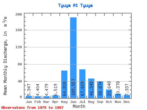
| Statistic | Jan | Feb | Mar | Apr | May | Jun | Jul | Aug | Sep | Oct | Nov | Dec | Annual |
|---|---|---|---|---|---|---|---|---|---|---|---|---|---|
| Mean | 5.35 | 4.40 | 4.48 | 6.52 | 64.82 | 189.56 | 67.61 | 46.35 | 38.87 | 20.65 | 10.38 | 7.34 | 38.77 |
| Standard Deviation | 1.20 | 0.92 | 0.68 | 1.69 | 37.56 | 55.75 | 28.75 | 15.99 | 12.84 | 5.17 | 2.58 | 2.10 | 6.24 |
| Min | 1.63 | 2.38 | 2.19 | 4.62 | 18.00 | 81.80 | 27.00 | 21.80 | 21.60 | 12.40 | 6.61 | 2.39 | 28.82 |
| Max | 7.07 | 6.24 | 5.72 | 12.20 | 165.00 | 320.00 | 140.00 | 80.90 | 68.90 | 33.80 | 15.70 | 11.00 | 50.61 |
| Coefficient of Variation | 0.22 | 0.21 | 0.15 | 0.26 | 0.58 | 0.29 | 0.42 | 0.34 | 0.33 | 0.25 | 0.25 | 0.29 | 0.16 |
 Return to R-Arctic Net Home Page