|
|
|||||||||||||||||
| Point ID: 6400 | Downloads | Plots | Site Data | Code: 7009 |
|
|
|||||||||||||||||
| Download | |
|---|---|
| Site Descriptor Information | Site Time Series Data |
| Link to all available data | |
| View: | Time Series | All |
| Units: | m3/s |
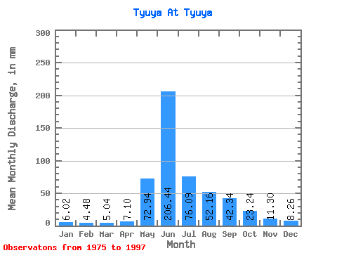
| Statistic | Jan | Feb | Mar | Apr | May | Jun | Jul | Aug | Sep | Oct | Nov | Dec | Annual |
|---|---|---|---|---|---|---|---|---|---|---|---|---|---|
| Mean | 6.02 | 4.51 | 5.04 | 7.10 | 72.93 | 206.44 | 76.07 | 52.15 | 42.34 | 23.23 | 11.30 | 8.26 | 514.11 |
| Standard Deviation | 1.35 | 0.94 | 0.77 | 1.83 | 42.26 | 60.71 | 32.34 | 18.00 | 13.99 | 5.82 | 2.81 | 2.36 | 82.77 |
| Min | 1.83 | 2.44 | 2.46 | 5.03 | 20.25 | 89.09 | 30.38 | 24.53 | 23.52 | 13.95 | 7.20 | 2.69 | 382.16 |
| Max | 7.96 | 6.40 | 6.44 | 13.29 | 185.66 | 348.50 | 157.53 | 91.03 | 75.04 | 38.03 | 17.10 | 12.38 | 671.08 |
| Coefficient of Variation | 0.22 | 0.21 | 0.15 | 0.26 | 0.58 | 0.29 | 0.42 | 0.34 | 0.33 | 0.25 | 0.25 | 0.29 | 0.16 |
 Return to R-Arctic Net Home Page