|
|
|||||||||||||||||
| Point ID: 6336 | Downloads | Plots | Site Data | Code: 3629 |
|
|
|||||||||||||||||
| Download | |
|---|---|
| Site Descriptor Information | Site Time Series Data |
| Link to all available data | |
| View: | Time Series | All |
| Units: | mm |
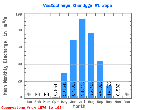
| Statistic | Jan | Feb | Mar | Apr | May | Jun | Jul | Aug | Sep | Oct | Nov | Dec | Annual |
|---|---|---|---|---|---|---|---|---|---|---|---|---|---|
| Mean | 0.85 | 29.64 | 67.97 | 93.42 | 76.42 | 44.02 | 14.72 | 0.53 | |||||
| Standard Deviation | 1.56 | 35.34 | 26.06 | 52.00 | 35.67 | 25.48 | 12.85 | 0.74 | |||||
| Min | 0.01 | 2.26 | 35.50 | 14.70 | 24.10 | 19.60 | 3.49 | 0.04 | |||||
| Max | 4.63 | 135.00 | 129.00 | 215.00 | 137.00 | 105.00 | 42.80 | 1.83 | |||||
| Coefficient of Variation | 1.83 | 1.19 | 0.38 | 0.56 | 0.47 | 0.58 | 0.87 | 1.39 |
 Return to R-Arctic Net Home Page