|
|
|||||||||||||||||
| Point ID: 6336 | Downloads | Plots | Site Data | Code: 3629 |
|
|
|||||||||||||||||
| Download | |
|---|---|
| Site Descriptor Information | Site Time Series Data |
| Link to all available data | |
| View: | Time Series | All |
| Units: | m3/s |
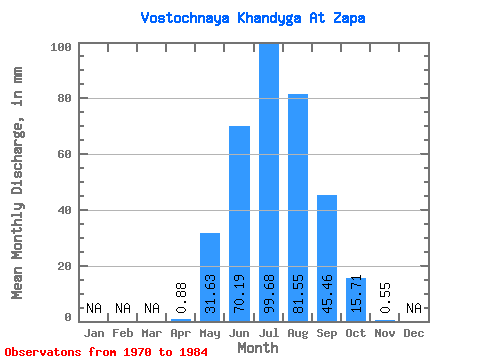
| Statistic | Jan | Feb | Mar | Apr | May | Jun | Jul | Aug | Sep | Oct | Nov | Dec | Annual |
|---|---|---|---|---|---|---|---|---|---|---|---|---|---|
| Mean | 0.88 | 31.63 | 70.19 | 99.67 | 81.54 | 45.46 | 15.71 | 0.55 | |||||
| Standard Deviation | 1.61 | 37.71 | 26.91 | 55.48 | 38.06 | 26.31 | 13.71 | 0.76 | |||||
| Min | 0.01 | 2.41 | 36.66 | 15.68 | 25.71 | 20.24 | 3.72 | 0.04 | |||||
| Max | 4.78 | 144.04 | 133.21 | 229.39 | 146.17 | 108.43 | 45.66 | 1.89 | |||||
| Coefficient of Variation | 1.83 | 1.19 | 0.38 | 0.56 | 0.47 | 0.58 | 0.87 | 1.39 |
 Return to R-Arctic Net Home Page