|
|
|||||||||||||||||
| Point ID: 6327 | Downloads | Plots | Site Data | Code: 3577 |
|
|
|||||||||||||||||
| Download | |
|---|---|
| Site Descriptor Information | Site Time Series Data |
| Link to all available data | |
| View: | Time Series | All |
| Units: | mm |
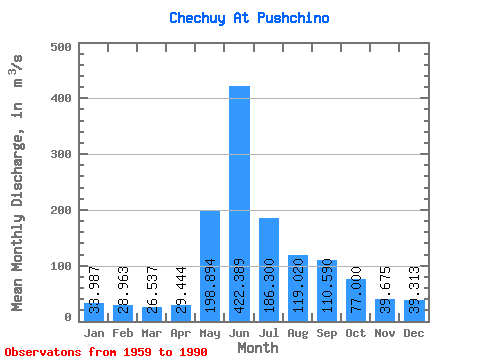
| Statistic | Jan | Feb | Mar | Apr | May | Jun | Jul | Aug | Sep | Oct | Nov | Dec | Annual |
|---|---|---|---|---|---|---|---|---|---|---|---|---|---|
| Mean | 33.99 | 28.96 | 26.54 | 29.44 | 198.89 | 422.39 | 186.30 | 119.02 | 110.59 | 77.00 | 39.67 | 39.31 | 114.55 |
| Standard Deviation | 5.63 | 4.26 | 2.96 | 9.04 | 91.17 | 193.41 | 64.51 | 31.34 | 36.30 | 19.25 | 5.87 | 4.73 | 18.32 |
| Min | 26.90 | 23.30 | 21.90 | 20.40 | 1.83 | 0.28 | 108.00 | 61.90 | 54.60 | 45.50 | 30.90 | 32.00 | 83.89 |
| Max | 44.10 | 34.80 | 30.40 | 51.50 | 315.00 | 641.00 | 307.00 | 172.00 | 169.00 | 108.00 | 46.90 | 44.30 | 140.36 |
| Coefficient of Variation | 0.17 | 0.15 | 0.11 | 0.31 | 0.46 | 0.46 | 0.35 | 0.26 | 0.33 | 0.25 | 0.15 | 0.12 | 0.16 |
 Return to R-Arctic Net Home Page