|
|
|||||||||||||||||
| Point ID: 6319 | Downloads | Plots | Site Data | Code: 3561 |
|
|
|||||||||||||||||
| Download | |
|---|---|
| Site Descriptor Information | Site Time Series Data |
| Link to all available data | |
| View: | Time Series | All |
| Units: | mm |
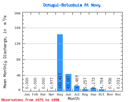
| Statistic | Jan | Feb | Mar | Apr | May | Jun | Jul | Aug | Sep | Oct | Nov | Dec | Annual |
|---|---|---|---|---|---|---|---|---|---|---|---|---|---|
| Mean | 0.00 | 0.00 | 0.00 | 0.98 | 143.44 | 43.19 | 13.47 | 5.26 | 8.17 | 4.75 | 0.94 | 0.03 | 19.26 |
| Standard Deviation | 0.00 | 0.00 | 0.00 | 2.48 | 84.93 | 34.00 | 16.60 | 5.23 | 10.32 | 6.62 | 1.85 | 0.11 | 11.22 |
| Min | 0.00 | 0.00 | 0.00 | 0.00 | 0.14 | 0.06 | 0.04 | 0.12 | 0.09 | 0.00 | 0.00 | 0.00 | 0.05 |
| Max | 0.00 | 0.00 | 0.00 | 8.38 | 278.00 | 114.00 | 53.80 | 15.90 | 32.90 | 19.60 | 4.83 | 0.40 | 39.89 |
| Coefficient of Variation | 2.54 | 0.59 | 0.79 | 1.23 | 0.99 | 1.26 | 1.39 | 1.98 | 3.61 | 0.58 |
 Return to R-Arctic Net Home Page