|
|
|||||||||||||||||
| Point ID: 6319 | Downloads | Plots | Site Data | Code: 3561 |
|
|
|||||||||||||||||
| Download | |
|---|---|
| Site Descriptor Information | Site Time Series Data |
| Link to all available data | |
| View: | Time Series | All |
| Units: | m3/s |
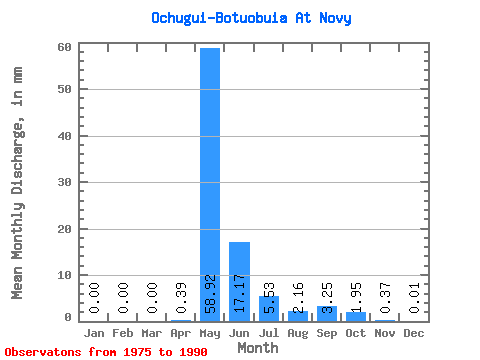
| Statistic | Jan | Feb | Mar | Apr | May | Jun | Jul | Aug | Sep | Oct | Nov | Dec | Annual |
|---|---|---|---|---|---|---|---|---|---|---|---|---|---|
| Mean | 0.00 | 0.00 | 0.00 | 0.39 | 58.91 | 17.17 | 5.53 | 2.16 | 3.25 | 1.95 | 0.37 | 0.01 | 93.24 |
| Standard Deviation | 0.00 | 0.00 | 0.00 | 0.99 | 34.88 | 13.52 | 6.82 | 2.15 | 4.10 | 2.72 | 0.74 | 0.05 | 54.32 |
| Min | 0.00 | 0.00 | 0.00 | 0.00 | 0.06 | 0.03 | 0.02 | 0.05 | 0.03 | 0.00 | 0.00 | 0.00 | 0.23 |
| Max | 0.00 | 0.00 | 0.00 | 3.33 | 114.19 | 45.32 | 22.10 | 6.53 | 13.08 | 8.05 | 1.92 | 0.16 | 193.10 |
| Coefficient of Variation | 2.54 | 0.59 | 0.79 | 1.23 | 0.99 | 1.26 | 1.39 | 1.98 | 3.61 | 0.58 |
 Return to R-Arctic Net Home Page