|
|
|||||||||||||||||
| Point ID: 6306 | Downloads | Plots | Site Data | Code: 3500 |
|
|
|||||||||||||||||
| Download | |
|---|---|
| Site Descriptor Information | Site Time Series Data |
| Link to all available data | |
| View: | Time Series | All |
| Units: | mm |
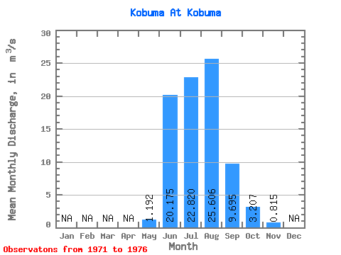
| Statistic | Jan | Feb | Mar | Apr | May | Jun | Jul | Aug | Sep | Oct | Nov | Dec | Annual |
|---|---|---|---|---|---|---|---|---|---|---|---|---|---|
| Mean | 1.19 | 20.18 | 22.82 | 25.61 | 9.70 | 3.21 | 0.81 | ||||||
| Standard Deviation | 0.58 | 12.46 | 12.13 | 17.85 | 6.06 | 1.86 | 1.15 | ||||||
| Min | 0.23 | 11.50 | 11.30 | 6.33 | 5.01 | 1.17 | 0.01 | ||||||
| Max | 1.79 | 38.10 | 40.40 | 54.40 | 18.60 | 4.89 | 2.45 | ||||||
| Coefficient of Variation | 0.49 | 0.62 | 0.53 | 0.70 | 0.62 | 0.58 | 1.41 |
 Return to R-Arctic Net Home Page