|
|
|||||||||||||||||
| Point ID: 6306 | Downloads | Plots | Site Data | Code: 3500 |
|
|
|||||||||||||||||
| Download | |
|---|---|
| Site Descriptor Information | Site Time Series Data |
| Link to all available data | |
| View: | Time Series | All |
| Units: | m3/s |
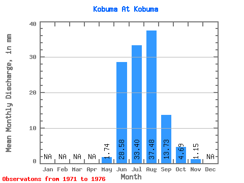
| Statistic | Jan | Feb | Mar | Apr | May | Jun | Jul | Aug | Sep | Oct | Nov | Dec | Annual |
|---|---|---|---|---|---|---|---|---|---|---|---|---|---|
| Mean | 1.74 | 28.58 | 33.40 | 37.47 | 13.73 | 4.69 | 1.15 | ||||||
| Standard Deviation | 0.85 | 17.65 | 17.75 | 26.12 | 8.59 | 2.72 | 1.62 | ||||||
| Min | 0.34 | 16.29 | 16.54 | 9.26 | 7.10 | 1.71 | 0.01 | ||||||
| Max | 2.62 | 53.97 | 59.12 | 79.61 | 26.34 | 7.16 | 3.47 | ||||||
| Coefficient of Variation | 0.49 | 0.62 | 0.53 | 0.70 | 0.62 | 0.58 | 1.41 |
 Return to R-Arctic Net Home Page