|
|
|||||||||||||||||
| Point ID: 6305 | Downloads | Plots | Site Data | Code: 3499 |
|
|
|||||||||||||||||
| Download | |
|---|---|
| Site Descriptor Information | Site Time Series Data |
| Link to all available data | |
| View: | Time Series | All |
| Units: | mm |
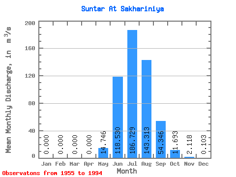
| Statistic | Jan | Feb | Mar | Apr | May | Jun | Jul | Aug | Sep | Oct | Nov | Dec | Annual |
|---|---|---|---|---|---|---|---|---|---|---|---|---|---|
| Mean | 0.00 | 0.00 | 0.00 | 0.00 | 14.75 | 118.53 | 186.73 | 143.31 | 54.35 | 11.69 | 2.12 | 0.10 | 44.44 |
| Standard Deviation | 0.00 | 0.00 | 0.00 | 0.00 | 16.93 | 50.56 | 73.86 | 63.49 | 26.57 | 4.53 | 1.55 | 0.21 | 12.41 |
| Min | 0.00 | 0.00 | 0.00 | 0.00 | 0.04 | 42.60 | 60.80 | 63.20 | 16.30 | 4.41 | 0.09 | 0.00 | 22.57 |
| Max | 0.00 | 0.00 | 0.00 | 0.00 | 77.50 | 231.00 | 402.00 | 291.00 | 134.00 | 25.70 | 8.46 | 1.03 | 77.49 |
| Coefficient of Variation | 1.15 | 0.43 | 0.40 | 0.44 | 0.49 | 0.39 | 0.73 | 2.06 | 0.28 |
 Return to R-Arctic Net Home Page