|
|
|||||||||||||||||
| Point ID: 6305 | Downloads | Plots | Site Data | Code: 3499 |
|
|
|||||||||||||||||
| Download | |
|---|---|
| Site Descriptor Information | Site Time Series Data |
| Link to all available data | |
| View: | Time Series | All |
| Units: | m3/s |
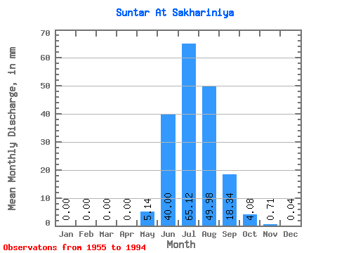
| Statistic | Jan | Feb | Mar | Apr | May | Jun | Jul | Aug | Sep | Oct | Nov | Dec | Annual |
|---|---|---|---|---|---|---|---|---|---|---|---|---|---|
| Mean | 0.00 | 0.00 | 0.00 | 0.00 | 5.14 | 40.00 | 65.11 | 49.97 | 18.34 | 4.08 | 0.71 | 0.04 | 182.64 |
| Standard Deviation | 0.00 | 0.00 | 0.00 | 0.00 | 5.90 | 17.07 | 25.75 | 22.14 | 8.97 | 1.58 | 0.52 | 0.07 | 51.01 |
| Min | 0.00 | 0.00 | 0.00 | 0.00 | 0.01 | 14.38 | 21.20 | 22.04 | 5.50 | 1.54 | 0.03 | 0.00 | 92.75 |
| Max | 0.00 | 0.00 | 0.00 | 0.00 | 27.02 | 77.96 | 140.18 | 101.47 | 45.23 | 8.96 | 2.85 | 0.36 | 318.42 |
| Coefficient of Variation | 1.15 | 0.43 | 0.40 | 0.44 | 0.49 | 0.39 | 0.73 | 2.06 | 0.28 |
 Return to R-Arctic Net Home Page